
|
|
 CHAPTER 24, Inc., MADISON, WI |
- Home
- Meetings
Schedule - Meeting
Minutes - Chapter
By Laws - Chapter
Officers -
Technical
Documents -
EAS
Info -
Chapter
Archives - Sustaining
Members -
Broadcasters
Clinic - DTV for
Consumers - Links
GEOSTATIONARY ORBITS PART 3: by Neal McLain, CSBE |
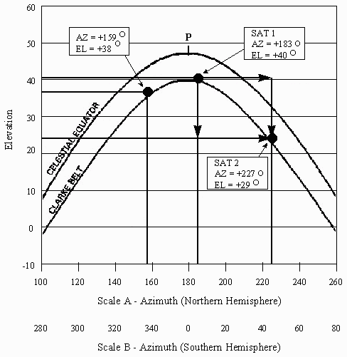 |
In this figure:
• Scale B shows the range of azimuths occupied by the Clarke Belt when viewed from the Southern Hemisphere (43° South Latitude), looking north. Note that the definition of azimuth holds worldwide: 0° azimuth is always true north, even in the Southern Hemisphere.
• Elevation is the vertical axis; it is calibrated in degrees above or below the horizon. Angles above the horizon are positive; angles below the horizon are negative. Satellites with negative elevations are, of course, not visible to an observer. Note that elevation is always measured along a vertical line; i.e., a line which is perpendicular to the horizon. The concepts of azimuth and elevation were borrowed from the field of astronomy. In astronomy:
• Azimuth is used to specify the position of an astronomical object, measured clockwise along the horizon from a specified reference point. North is generally used as the zero reference point, although some authors define south as the zero reference.
• Elevation is called "altitude" in astronomy, but it means the same thing: the angle to an astronomical object above the horizon, measured along a line which is perpendicular to the horizon.
HOUR ANGLE and DECLINATION
By definition:
• Declination is the angle, in degrees, between the Celestial Equator and a satellite, measured along a line which is perpendicular to the Celestial Equator. Declination is always:
POSITIVE for antenna sites located in the Southern Hemisphere (why?).
ZERO for antenna sites located on the Equator.
 |
This is our familiar view of the sky, as seen from 43° latitude. The axes are azimuth and elevation.
The hour angle to any given satellite is the angle between the following points on the Celestial Equator:
• Point P: The peak point of the Celestial Equator. This point lies directly south of an antenna located in the Northern Hemisphere, and directly north of an antenna located in the Southern Hemisphere.
• 0° azimuth is always north; 0° hour angle is always toward the equator.
• Azimuth is always a positive number; hour angle can be either positive or negative.
Declination is analogous to elevation in that both terms specify the position of a satellite above or below some specified reference point. But there are three significant differences:
• 0° elevation is the horizon; 0° declination is the Celestial Equator.
• Elevation is positive if the satellite is above the horizon (and negative if it's below); declination is positive if the antenna is located in the Southern Hemisphere (and negative in the Northern Hemisphere).
The concepts of hour angle and declination were borrowed from the field of astronomy. In astronomy:
• Hour angle has a similar meaning. However, things are a lot more complicated in astronomy, because, unlike geostationary satellites, astronomical objects are in constant motion: they rise in the east and set in the west. Thus, the hour angle to any given object changes continuously, depending on the time and date. This, of course, accounts for the name "hour" angle.
• Declination is used to specify the position of an astronomical object, in degrees, north or south of the Celestial Equator. Angles to objects north of the equator are positive; angles to objects south of the equator are negative.
SATELLITE ANTENNA MOUNTS
Antenna mount is the name given to the mechanism which supports a ground-based satellite antenna. Ideally, the mount must allow the antenna to be adjusted precisely to the specified pointing angles, and it must hold the antenna securely in that position.
In Part 4, we'll discuss antenna mounts in detail.
Orbits Index Page